Morbe Dam and Wavarle

 There is a sunrise and sunset, every single day and they are absolutely free. Don't miss them!! A journey is best measured in happiness and not in kilometers. Have you heard these two quotes?!!

 Morbe


Pleasantly cool weather welcomed us. The mountains, the forest, the water reservoir and the fresh air.. what else one needs for a good start of the day!! I am sure, even the Sun must be thinking on the same lines!! 


From the wall of Morbe dam


We were on the wall of Morbe Dam. It's a good walking track. Visitor's are not allowed except the morning walkers till around 8 a.m. We reached there really early in the morning. 

Morbe dam is a dam built on Dhavari river, near Khalapur in Raigad district of Maharashtra, India. It is a gravity dam. Though it is not one of the few gravity dams, surely it is one of the new gravity dams in Maharashtra. Dhamapur in Sindhudurg district is one of the oldest dams in Maharashtra in modern times. The construction of Dhamapur dam started around 1530 and the dam is operational since 1600. But it was earth fill type of dam.

In ancient times, we can find references of Kallanai Dam built by Chola kings in 100 B.C.-100 A.D. This dam was built on Kaveri river near Thanjavur and it is still in use. Water of the Kaveri river was diverted and used for irrigating the land. 

The first reference of gravity type dams in Maharashtra in modern times is of Tulashi dam built on Tulashi river in Mumbai in 1879. 

This Morbe dam is comparatively new dam which became operational in 2006. Gravity dams can be built only in those places where the foundation can be really strong. It is a stone masonry structure designed to withstand load by it's own weight. 

Morbe dam provides water to Navi Mumbai and is owned by Navi Mumbai Municipal Corporation. Most probably it is the only municipal corporation owning a dam! 
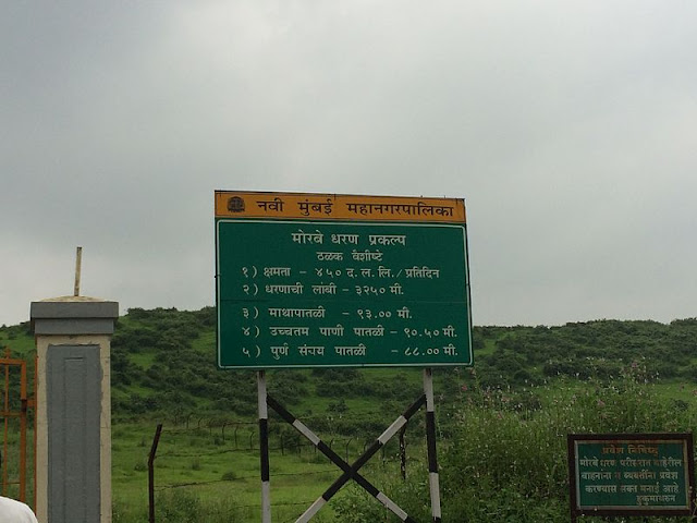
Details of the Dam
📷 Wikimedia Commons


Setting Moon 01/11/20


It was surely a wonderful morning with the full moon of Kojagiri pornima preparing to set. This photo was taken at 6.26 a.m. You can see the stone masonry wall of the reservoir as well. On the other side, the Sun was about to rise. 

Sunrise 01/11/20


The wonderful ambience, though could not be captured by any camera, I have tried to do it with my humble mobile phone. 


For capturing all these early morning views and enjoy the amazing ambience, we had reached in nearby village called Wavarle on the previous day. It is a small village and is at a distance of 10 minutes by car. 

The village is situated on the Chowk-Karjat Road in Khalapur district. We had stayed in Sathe Farm. The place was a peaceful oxygen bank with many huge trees and spacious enough to maintain social distance!

Flowers in Sathe Farm


Dense canopy of trees on Sathe Farm

The greenery 

This region is lucky to have scenic beauty with hills and mountains, water reservoirs and greenery. A short walk of about 15/20 minutes takes you to this reservoir. The road starts from the mango groves, then through wilderness, reaches the reservoir. Surely you won't experience fresh air like this in city. 


This is a reservoir where rain water is collected. This region is bestowed with heavy rainfall, so in rainy, one can see many waterfalls in this area!

Panoramic view of reservoir 

When you can see only the vast spread of grass, mountains and water, you can actually feel the sense of freedom!

The wilderness

There is a small temple of Ganesh and Shiv. Though the construction of the temple is new, the Shivpindi and Nandi look like they have witnessed a long time period. 

The Temple

Still it's time to set, just sun is trying to go behind the mountains!

Sun about to set!! 31/10/20


What a better way to end the day with the rising full moon??!

Full moon from the dining area of the resort! 31/10/20

While enjoying the delicious Vegan food at the resort, we could see the full moon from the table. This was surely the cherry on the top!

Sondai Fort is at a 2 hrs trek from the place. the difficulty level is easy to medium. Kondhane Buddhist caves are at half an hour drive. May be we will visit both these places in our next trip. 

 As I have said in the starting of the post, journey is not measured in kilometers, it's measured in the happiness. A short one and half day tour, just to a place about 50 km from your home, rejuvenate you!! 

#ShortTripFromMumbai #ShortTripFromThane #ShortTripFromPune #SatheFarmsSatishSathe07738342820 #PlacesToVisitNearKarjatKhopli

Comments

Popular posts from this blog

देवरियाताल चंद्रशिला ट्रेक- भाग 1 - तयारी !!

  आपण स्वप्न पाहतो… आपण स्वप्ने पाहतो… त्यातील एखाद दुसरेच प्रत्यक्षात यावे म्हणून धडपडतो आणि बाकीची स्वप्ने कधीतरी नवलाईने आंजारायला गोंजारायला असावीत म्हणून त्यांना स्वप्न म्हणूनच राहू देतो.  हाय अल्टिट्युड ट्रेक हे माझे एक असेच स्वप्न होते, नेहमी भुरळ पाडणारे आणि तरीही प्रत्यक्षात आले तर इतक्या उंचीवर चालताना काहीशी धास्तीच वाटावी असे. त्यामुळे वर्षानुवर्ष ते स्वप्न प्रत्यक्षात न येता स्वप्नच राहिले होते.  नोव्हेंबरमध्ये माझी मैत्रीण धनश्री जगताप इंडियाहाईक्सबरोबर देवरिया ताल चंद्रशिला हा ट्रेक करून आली. तिच्याशी गप्पा मारताना या ट्रेकची सविस्तर माहिती मिळाली. मार्च एप्रिलमध्ये या संपूर्ण रस्त्यावर ऱ्होडोडेंड्रॉनची फुले फुललेली असतात असेही कळले… आणि मनातल्या स्वप्नाला पुन्हा एकदा जाग आली.  असे म्हणतात की देवरिया ताल म्हणजे जिथे यक्षाने युधिष्ठिराला प्रश्न विचारले ते तळे. वाटेत लागणारे तुंगनाथ हे तर जगातले सर्वात उंचावर असणारे शंकराचे मंदिर, पंच केदारापैकी एक. हे पांडवांनी बांधले आहे असे सांगितले जाते. ट्रेकचा समिट पॉईंट म्हणजे चंद्रशिला. जिथे चंद्राने तपश्चर्या केली ती जागा. असेही म

देवरियाताल चंद्रशिला ट्रेक - भाग 2 - सारी - देवरियाताल

दुसऱ्या दिवशी सकाळी ट्रेकला सुरुवात झाली तीच एका तीव्र चढणीने!! चढताना एका क्षणी मागे वळून आम्ही सारी बेस कॅम्पचा निरोप घेतला. परत येउ तेव्हा ट्रेक यशस्वीरित्या पूर्ण केला असेल की नाही, ते माहिती नव्हते. पण अनुभवसमृद्ध मात्र नक्की होऊन परत येऊ ह्याची ग्वाही मनातच दिली. सारी बेस कॅम्प 📷 Supan Shah रस्ता ओबडधोबड दगडांनी तयार केलेला होता. पण भुसभुशीत मातीत पाय घसरण्यापेक्षा दगड परवडले असे मनाला सांगत चढण चढत होते. 📷 Pawan Gowda ह्या फोटोवरून चढ किती होता त्याचा तर अंदाज येईल पण आम्ही सगळे कसे चढत होतो ते कळायचे असेल तर व्हिडिओ आहे ना! विडिओ - सम्राट दर्डा https://youtube.com/shorts/CJuWDSml8XU?feature=share रस्त्याचा सुरुवातीचा काही भाग लोकवस्तीतून जाणारा. पण तेथील घरेही अगदी तुरळक आणि तशी लांब लांब. हिरवीगार शेते मात्र दिसत होती. डोंगर उतारावर पायऱ्यांसारखे बांध घालत केलेली ही शेती संपूर्ण उतार जिवंत करत होती. The view 📷 Supan Shah 📷 Samrat Darda तासभर तीव्र चढणीचा रस्ता पार केल्यानंतर थोडया वेळाने तुलनेने जरा सपाट भाग आला तेव्हा हृदयाने थँक्यू म्हणायला सुरूवात केली!! तिथून चंद्रशिल

देवरियाताल चंद्रशिला ट्रेक - भाग 3 - देवरियाताल -स्यालमी

ट्रेकचा तिसरा दिवस. कालचा सारी- देवरियाताल प्रवास तर खूपच छान झाला होता. पायही दुखले नव्हते की थकल्यासारखे देखील वाटले नव्हते. त्यामुळे उत्साहाने आजच्या दिवसाला सुरुवात केली. आजचा दिवस तसा अवघड असेल अशी, इंडियाहाईक्सच्या  वेब साईटवरचे वर्णन वाचून कल्पना आली होती. आज अंतर नऊ किलोमीटरपेक्षा जास्त होते. पण वाटेत अनेक शिखरे दिसणार होती. घनदाट जंगलातून जाणार होतो त्यामुळे अनेक पक्षीही दिसणार होते. त्याचीही उत्सुकता होती. सगळेजण देवरियाताल कॅम्पसाईट मधून बाहेर पडलो. अवघे एक दिवस वास्तव्य केलेले असले तरी मन थोडेतरी गुंतलेले असतेच.  देवरियातालच्या रस्त्याच्या डाव्या बाजूने एक जंगलवाटेचा फाटा होता. त्या वाटेने आम्ही निघालो. थोडा वेळ चालल्यावर आम्हाला पुन्हा एकदा चंद्रशिला शिखर दिसणार होते. अधून मधून दिसणारे हे शिखर आपल्याला कुठे पोचायचे आहे त्याची जाणीव करून द्यायचे, त्यानेही एक नवे बळ मिळायचे. पण आज आकाश इतके ढगाळ होते की शिखर दिसलेच नाही.उजवीकडे पुन्हा एकदा सारी गाव मात्र दिसले. 📷Cotrekker 📷Sumati Dhembre ह्या फोटोवरून कशा रस्त्याने आम्ही चालत होतो, चढ किती होता त्याची कल्पना येईल. (सर्वात

देवरियाताल चंद्रशिला ट्रेक - भाग 5- अंतिम भाग - बनियाकुंड- तुंगनाथ- चंद्रशिला

  📷Samrat Darda १५ एप्रिल, बनियाकुंड कॅम्पसाईट मधून काढलेला चंद्राचा सुंदर फोटो. त्या दिवशी शुक्ल पक्षातील सप्तमी किंवा अष्टमी असावी. कारण १७ एप्रिलला रामनवमी होती. सुंदर काळ्याभोर रात्रीचा सघन अंधार.. पौर्णिमा अजून साताठ दिवसांवर असली तरीही आत्तापासूनच तेजाळलेला चंद्र.. चमचमणारे, मध्येच ढगांच्या आड लपणारे चांदणे, आमच्या मनातील समिटविषयीची उत्सुकता..फार अनोखी रात्र होती ती.  उद्या पहाटे दोन वाजताचा वेकप कॉल असणार होता. आम्हाला आवरून, ब्रेकफास्ट करून तीन वाजता निघायचे होते. न विसरता घेण्याच्या गोष्टी तशा तर डे पॅक मध्ये भरूनच ठेवल्या होत्या. हेडलॅम्पच्या उजेडात सामान देखील आवरून ठेवले होते. पहाटे निघताना बाकी सामान मेन टेन्ट मध्ये नेऊन ठेवायचे होते.  इतक्या उंचीवर जायचे होते. काही तासांत आम्ही ४००० फुटांचा अल्टीट्युड गेन करणार होतो. झोपण्यासाठी डोळे मिटले खरे, पण मिटल्या डोळ्यांपुढेही बर्फाच्छादित शिखरांचीच दृश्ये तरळत होती. कधीतरी झोप लागली. सतत अधूनमधून जाग येऊन घड्याळात बघत होते. सगळे दोन वाजता उठणार, त्या आधी आपण आपले आवरून घेऊ या असा विचार डोक्यात होता तो बहुधा सतत जाग आणत असावा!!

देवरियाताल चंद्रशिला ट्रेक - भाग 4 - स्यालमी - बनियाकुंड

आदल्या संध्याकाळी भुरभुरत असलेल्या पावसाने हवेतला गारवा अजूनच वाढवला होता. इतक्या लहान तंबूमध्ये झोपण्याची पहिलीच वेळ होती. पण सुरुवातीचे दोन तास सोडले तर नंतरचे पाच तास चांगली झोप झाली. अगदी प्रसन्न जाग आली.काल एकदाच क्षणभर का होईना, मनात तरळून गेलेला,"आपण ट्रेक इथेच थांबवावा का?"ह्या विचाराचा आज कुठे मागमूसही उरला नव्हता. मनात होते,  "इरादे अगर पक्के हो, तो डगमगाए कदम क्यु? हौसले बुलंद हो तो सहमा सा हो मन क्यु? मंज़िल अब दूर नहीं.. बस संभल के चलना, कभी न रुकना, हार ना मानना, बस्स .. चलते रहना।" - वृंदा टिळक आमच्या सगळ्याच कॅम्पसाईट्स भन्नाट जागांवर होत्या. आजची स्यालमीची कॅम्प साईट देखील त्याला अपवाद नव्हती. नजर पोचेल तिथपर्यंत फक्त पर्वत रांगा आणि जंगल. मानवी वस्तीची जवळपास काहीच चाहूल नाही.  📷Samrat Darda  सगळ्यांचे आवरून वॉर्म अप करून आम्ही निघालो. आजचा सगळा रस्ता सुंदर असणार होता. काल इतके चढ उतार चढून उतरून आता सगळ्यांची चांगली तयारी झाली होती. शिवाय आज मी नीकॅप्स देखील घातल्या होत्या!! त्यामुळे समजा जरी आज रस्ता अवघड असला असता तरी काळजीचे काही कारण नव्हते.

ग्यानबोक पॅलेस, सेऊल, साऊथ कोरिया

राष्ट्रीय अस्मितेची चिन्हे परकीय आक्रमक पुसून टाकायचा प्रयत्न करतात, करतातच. जगभर अशी असंख्य उदाहरणे सापडतील. कारण त्याशिवाय त्यांना त्यांची सत्ता निर्माण करता येणार नसते. पण मग त्या त्या देशातील, देशावर प्रेम असणारे लोक काय करतात हे जाणून घ्यायचे असेल तर एक उदाहरण सांगते. आपल्याला सेऊल मधील ग्यानबोक  पॅलेस याच्याविषयी वाचायला हवे. ------------- तसा पोचायला आम्हाला थोडा उशीरच झाला होता. शेवटची इंग्लिश गाईडेड टूर चुकते की काय अशी भीती वाटायला लागली होती. अनेक कोरियन युवक युवती राजवाड्याकडे जाताना दिसत होते. विशेष म्हणजे त्यांनी पारंपरिक कोरियन पोशाख घातले होते. फार छान दिसत होते ते सगळे. आम्ही गेलो होतो, कोरियाच्या सार्वभौमत्वाचे मानचिन्ह असलेल्या ग्यानबोक पॅलेसला ( Gyeongbok Palace ) भेट देण्यासाठी.  तिकिटाच्या काउंटर जवळच राजवाड्याचे मुख्य प्रवेशद्वार आहे. त्याचे नाव आहे ग्वान्गमन गेट.( Gwanghwamun) . सेऊलच्या पुरातन इतिहासाचे प्रतीक असलेले हे प्रवेशद्वार १३९५ मध्ये बांधले गेले आहे. आज हे प्रवेशद्वार कोरियाची ओळख बनलेले आहे. कोरियाच्या वास्तुशास्त्राप्रमाणे, कोरियाची भरभराट व्हावी म्ह

Deoriatal - Chandrashila trek - Part 1 - Preparation

We dream… we dream about many things … but we strive to make only few of them a reality and leave the rest of the dreams as dreams only, to cherish them someday in our leisure time. A high altitude trek was one such dream of mine, always enthralling and yet a little daunting. So for years that dream remained a dream without becoming a reality. In November, my friend Dhanshree Jagtap did the Deoria Tal Chandrashila trek with Indiahikes. While chatting with her, I could get detailed information about this trek. She told that in March and April, rhododendron flowers will be blooming in this region … and the dormant dream was awakened once again. It is said that DeoriaTal is the lake where the famous Yaksha and Yudhishthira conversation had taken place. On the way to the summit, Tungnath is the highest temple of Shankara in the world, one of the Panch Kedars. It is said to have been built by the Pandavas. The summit point of the trek is Chandrashila. The place where Chandra did Tapas. It i

नागाव

  नागाव म्हणजे माडापोफळींच्या वाड्या. नागाव म्हणजे केळीच्या बागा. नागाव म्हणजे सुंदर स्वच्छ समुद्रकिनारा.  नागाव म्हणजे वस्त्रगाळ मऊ वाळूचा किनारा.  नागाव म्हणजे अनेक मंदिरे. नागाव म्हणजे लक्षवेधी दीपमाळा. नागाव म्हणजे कोपऱ्या कोपऱ्यावर भेटणारे तळे! नागाव म्हणजे तळ्यात फुललेलीअनेकानेक कमळे!! नागावच्या शेजारचे  अक्षी, चौल, रेवदंडा ही देखील अशीच गावे. नितांतसुंदर, साधी. अलिबाग आणि ह्या सर्व गावांना मिळून अष्टागर असे म्हणत असत. आठ गावांचा समूह.  अलिबाग पर्यटन स्थळ म्हणून ७० च्या दशकापासूनच प्रसिद्ध झाले होते. तेव्हा शांत निवांत असलेले अलिबाग नंतर खूपच गजबजले आणि मग दुसऱ्या सहस्त्रकात अलिबागशेजारील रेवदंडा, नागाव, चौल ही लहान लहान गावे देखील पर्यटनस्थळे म्हणून विकसित होऊ लागली.  ह्या निवांत, शांत गावांना जणू अचानक खडबडून जाग आली. तिथेही पर्यटकांची गर्दी वाढू लागली. स्थानिक लोकांना रोजगार, विकासाची संधी, अर्थार्जनाची संधी त्यात दिसली.  गावांवर आधुनिक पेहराव चढला आणि तिथे उदयाला आली मुंबईकरांची आवडती पर्यटनस्थळे.  आता तर परिस्थिती अशी आहे की जवळ जवळ एका आड एका वाडीत आपल्याला रिसॉर्ट झालेला द

हम्पी- विठ्ठल मंदिर

तुंगभद्रा नदीच्या काठावर वसलेले  हम्पी . तिसऱ्या शतकापासून ह्या शहराचे उल्लेख आहेतच.  चौदाव्या शतकातल्या विजयनगर साम्राज्याची राजधानी असलेले  हम्पी .  विजयनगर साम्राज्यासोबतच  या शहराची देखील प्रगती  झाली आणि जगातले  एक अत्यंत श्रीमंत, भरभराटीला आलेले शहर म्हणून हम्पी मान्यता पावले. विदेशातून देखील व्यापारी  हम्पी ला येत असत.  चौदाव्या शतकाच्या आधीदेखील तिसऱ्या शतकापासून इतकेच काय, अगदी रामायण कालात देखील  हम्पीचे  उल्लेख आपल्याला सापडतात. अजून देखील ऋष्यमुक सारखी पर्वतांची नावे असतील किंवा पम्पा सरोवर, किष्किंधा अशी ठिकाणांची नावे असतील, आपल्याला सतत रामायणाचा संदर्भ दिसत राहतो. हनुमानाचे जन्मस्थान, राम लक्ष्मण हनुमानाला भेटले ते ठिकाण देखील ह्याच परिसरात आहे. त्यामुळे अनेक भाविक नेहमीच  हम्पी ला भेट देत असतात. इतिहास संशोधकांसाठी, कलेच्या अभ्यासकांसाठी देखील  हम्पी  फार महत्त्वाचे आहे ते त्यातील एकाहून एक सुंदर, कोरीव काम असलेल्या मंदिरांमुळे! युनेस्कोने देखील या संपूर्ण भागाला जागतिक वारसा स्थळ म्हणून मान्यता दिलेली आहे.  हम्पीतील  खरे तर सगळीच मंदिरे पाहण्याजोगी आहेत इतकेच काय तिथ

Deoriatal Chandrashila trek - Part 2- - Sari to Deoriatal.

The next morning, the trek started with a steep climb!! At one point during the climb, we turned back and bade goodbye to the Sari base camp. It was not known whether we would successfully complete the trek or not. But I was sure that we will definitely come back with a life changing experience.   Sari Base camp  📷 Supan Shah The road was paved with rough stones. But while climbing I was telling myself that these stones were better than walking in the slippery soil. 📷 Pawan Gowda You can guess how much the climb was, from this photo, but if you want to know how we were climbing, there is a video! विडिओ - सम्राट दर्डा https://youtube.com/shorts/CJuWDSml8XU?feature=share The initial, few meters part of the road passed through populated areas. But the houses there were very few and sparse. Green fields were visible everywhere. Farming was done on the mountain slopes, by step method. This greenery enlivened the entire slope. The view 📷 Supan Shah 📷 Samrat Darda After walking on the ste