A beautiful photograph of the moon taken from Baniyakund campsite, April 15. That day should be Saptami or Ashtami of Shukla Paksha. Because Ram Navami was on 17th April. In the intense and tranquil darkness of the beautiful night, though the full moon day was still seven or eight days away, the moon was already bright. The shining moon, occasionally hiding behind the clouds, the curiosity of the summit in our minds.. it was a very unique night.
There was going to be a two o'clock wakeup call tomorrow. we had to pack up, have breakfast, and be ready to leave for the day at three o'clock. I packed the essential things in the day pack and packed everything else in the bag to be offloaded. That bag was to kept in the main tent while leaving in the morning.
Tomorrow, in few hours we would gain an altitude of 4000 ft. I closed my eyes to sleep, but even before my closed eyes, the images of the snow-capped peaks were floating.
I woke up at quarter to two in the morning and opened the tent without making a noise, so as not to disturb my tentmate. When I went to Sneha's tent and called her, she was already awake. Then we both went towards the bio toilets. At every campsite, there were bio toilets and they were never near our tents! After a short walk, uphill or downhill, there were the toilet tents. Baniyakund campsite was no exception. We went to the toilet tents in the pitch darkness of two o'clock in the morning. Only light was, our headlamps. Sneha felt that something is shining in the trees. But when she looked for it again, she didn't see anything. In such total darkness and in the surrounding dense forest, even if there was anything, it would not be noticed.
At two o'clock there was a wakeup call. Everyone started waking up. We had breakfast, packed our snacks. Now two friends who had gone to the toilet, came running to the main dining tent. They were out of breath after running fast. They had seen glowing eyes and some animals near the toilets. The trek leader told them that the animals won't do anything. If you don't bother them, they don't harm anyone. So to see what was there, many of us, along with trek leader went there. In the nearby bushes, there were indeed two/three animals. we couldn't see see which the animals were they, due to the insufficient light. In this way, the desire to see wild animals on the trek was also fulfilled!!
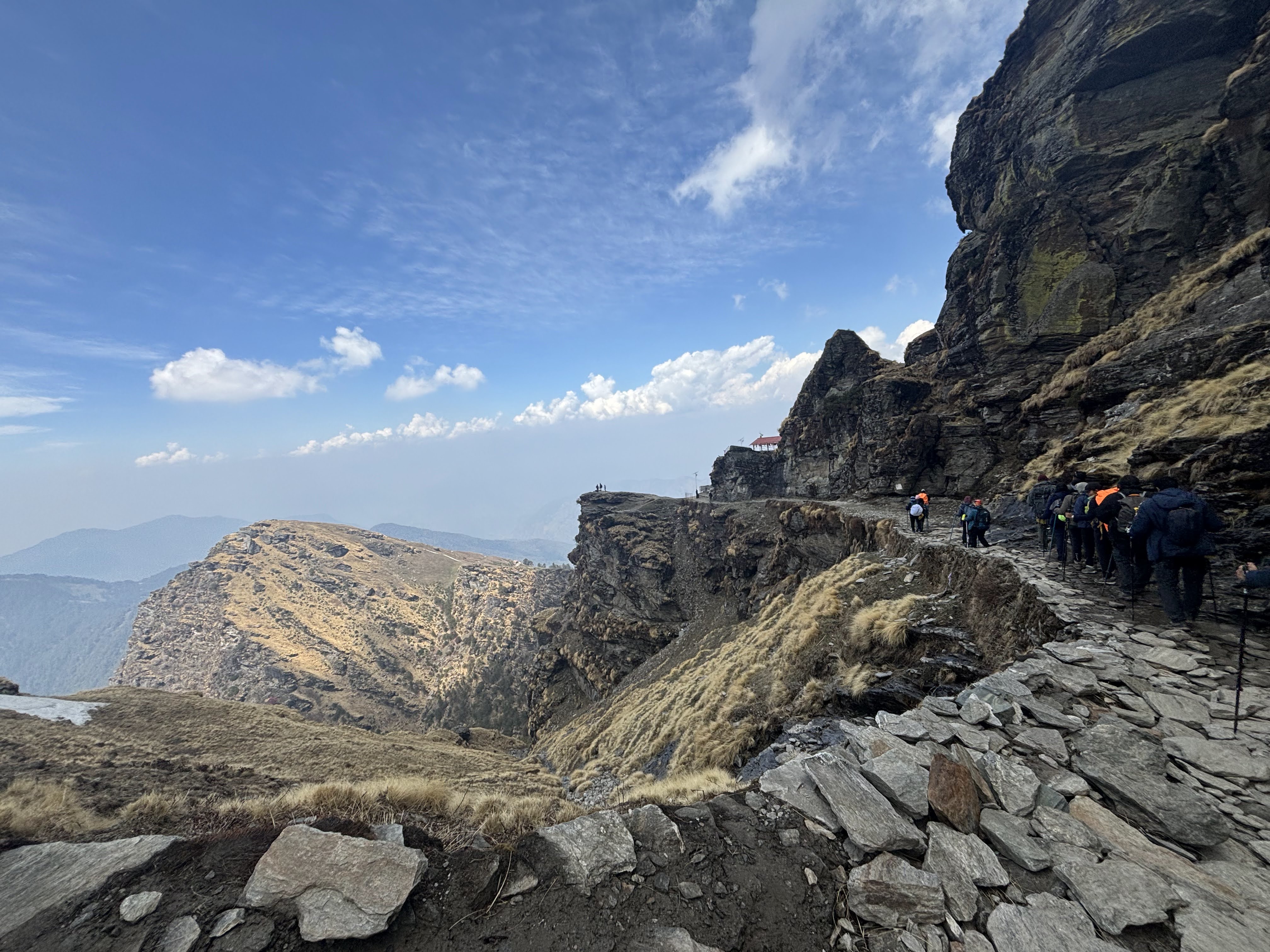
We left the campsite at three/ quarter past three. We were walking in the dark, in the light of our head lamps. Walking in a line of twenty-five gave us a sense of courage. Otherwise, the darkness, practically partially visible road, the hilly terrain, the climb, rough rocks, the valley, anyone alone would not have dared at all.
We had a time limit today. In the Himalayas and at such a height, one won't know when the season will change. If it rained a lot, stormed, or snowed, it would have taken us longer to walk. We were told that even if we did not reach Chandrashila by half past nine, we would start our return journey from wherever we were at 9.30. So no one was lingering today. I was walking at number two position in the group. The trek guide was first. So I felt a special urge to walk faster. The sooner we will reach at Chandrashila peak, the more time we would have at the summit.
After climbing a lot, after an hour we found a place where we could sit and rest for a couple of minutes. One dog was walking with us. He also stopped. Now it was 4.15a.m.
📷Co trekker
All this time we could not see anything around us. Because we were walking through the mountains. But now the lights of Chopta city were seen from this place.
📷Co trekker
Popularly known as Mini Switzerland, Chopta is a favorite tourist destination. There is a motorable road from Rudraprayag to Chopta. So everyone can go there. There are many resorts and hotels.
After a while we crossed Chopta. We passed by many houses and hotels and a lot of garbage was also seen. When we were walking in the forest for three/ four days, we never saw any garbage. It was once again realized that man pollutes wherever he goes.
After Chopta, the road up to Tungnath was paved with stones. So even though it was uphill, it felt relatively easier than the forest paths.
Now it was half past five. The sky was now illuminated with a dash of brightness. The outlines of mountain peaks and trees were now visible.
📷Co trekker
As we had started in the pitch dark, we could notice the difference vividly. The light was increasing literally minute by minute. The surroundings looked magical in that changing light.
📷Co trekker
📷Sumati Dhembre
It was now six o'clock. Now the peaks of the mountains started to glow with the light. We had not seen the sun yet.
📷Kedar Tembe
Now we got five minutes to rest. We could see the wonderful scenery around us. The path was uphill. But it was manageable as it wasn't a very steep climb.
📷Sumati Dhembre
Now a little snow appeared occasionally. We also saw a pair of Himalayan Monal birds. Monal birds are brightly colored males and brown monochromatic females. I saw that bird for the first time.
📷Samrat Darda
Male Monal's body colour was reminiscent of a peacock, its neck and tail even more distinctly colored, the vibrant color scheme was eye-catching. The photo is not that clear. Because the bird was too far away and it was moving too fast.
Now we could see Tungnath temple and Chandrashila.
📷Preeti Thakur
📷Co Trekker
He was still with us! no one would know, how many rounds he does every day! Other people were also seen on the way to Tungnath so was the garbage. Empty food packets, tissue papers, plastic bottles and many other things were thrown around. However, the Tungnath temple was still closed. Most of the shops were closed. So at present, the visitors are mostly tourists and trekkers. Still, there was so much garbage. When the temple opens in May, so will the shops. Crowd of people will increase. How much waste will there be then?
You will see in the photo that we all have yellow bags around our waists. They were eco bags provided by Indiahikes. We used to collect garbage along the way and then sort and deposit it in different bins which were kept at the campsite. Indiahikes has so far collected tons of such waste. In the mountain valleys of the Himalayas, there are no municipalities to take care of the garbage! From the campsites, once in a month, an organization collects it and takes it away. This was a glimpse of IndiaHikes' awareness and eco-friendly policies. In addition to this, we were asked to carry the personal waste that we would generate in our own bags to our respective cities.
It was now quarter to seven. We have walked on mostly uphill road. Now we were given time for snacks.
📷Preeti Thakur
Now the snow that was visible around had increased in quantity as well as frequency.
📷Co Trekker
Due to the steep climbs, winding roads, thinning air, some of our teammates started showing mild symptoms of high altitude sickness. They had mild headache. One of our teammates, had to go back to Baniyakund camp earlier today due to stomach cramps and nausea. We all remembered that teammate every now and then. After trekking for last 3/4 days, we felt sad that he could not make it on today's summit day. But we consoled ourselves saying that he will surely complete this trek again sometime.
The uphill road continued. A debate was going on in the mind whether the stone-built road was easier to climb or the hilly path was easier to climb. It was decided that hilly paths are more interesting even though they are difficult to climb. While the stone path seems easy to walk but they are boring. Of course, today the scenery was so picturesque that there was no room to get bored. Snow capped peaks were visible even below our eye level. Such a vast and magnificent region spread out before us! Now, we could see sun as well.
📷Kedar Tembe
In this beautiful photo, the Sun, Tungnath Temple and Chandrashila peak can be seen in a row. The climate was changing every moment. Sometimes it was foggy, sometimes cloudy, so the photos were not so clear. But it was good that at least it wasn't raining or snowing and there wasn't a storm. We were hoping to stay a little longer at the summit. We had heard stories of a previous team only being able to stay on the summit for a minute due to adverse weather conditions.
📷Kedar Tembe
It was half past seven now. It was four hours since we started walking. But now the Tungnath temple could be seen very close by. So the excitement and stamina could be sustained.
📷Preeti Thakur
Our trek guide Pramodji also played an important role in maintaining our enthusiasm. He was constantly motivating us by saying "keep going, keep going, push yourself, now we have almost reached!" Pramodji, Trek Leader Sahil and Trek Guide Amitji guided our team time and again and never failed to motivate us. They tried very earnestly and wholeheartedly to ensure that our trek would go smoothly.
Now everyone was huffing and puffing because the climb was very steep.
📷Preeti Thakur
📷Co Trekker
We were going straight to Chandrashila without stopping at the temple. We wanted to reach there before the mood of the air changed. The journey so far had gone according to plan. The journey so far had been just in time. Now it seemed that the next leg of the trek will also be covered in time. Now there was no paved road to walk on. It was hilly path. But anyways, we could not see the path as it was covered with snow!
📷Co Trekker
📷Co Trekker
"You walk so slowly, I have reached and sitting here since ages!! Now let me look at the beauty of the nature for a while." Isn't the dog saying so? Is this the same one coming with us from the base i.e. Baniyakund camp or is this different dog? How to know? Both are having same black coat!!
The snow-capped peaks seen everywhere, the vastness of the sky and the earth, the gigantic space, the meagreness of one's own existence, all these feelings flooded the mind. The view from Chandrashila peak is definitely amazing. But the way to Chandrashila is also very beautiful with such views.
📷Co Trekker
📷Co Trekker
But within a few moments, instead of looking at the scenery, we were looking at our footsteps!! Because now we had to walk through the snow. We had to tread carefully, following the footprints.
📷Co Trekker
📷Co Trekker
📷Co Trekker
The snow which looks beautiful from afar tests one when walking on it. Someone like me, living in a hot and humid climate rarely gets to experience walking on snow, so it was fun. But while walking on snow, the speed automatically decreased a little. Now it was 9 o'clock. The climb was too steep. Within few minutes we reached the peak.
I can't think of appropriate words to describe the view. and the feeling. It was simply amazing, out of this world!! This peak is one of the very few places from where we can get a 360 degree view of the Himalayas. The mountain ranges of Garhwal and Kumaon can be seen from here. Many prominent peaks are visible. Nandadevi, Choukhamba, Dronagiri, Neelkanth, Trishul, Kedarkantha, Gangotri ranges and many more.
I had thought that it would be an overwhelming happiness or joyful excitement to reach there. But actually, when we reached there, I was speechless with the sight. Mind was a bit stoic. After regaining some awareness, the first feeling was of immense gratitude for being able to experience this scene.
Now of course it was photo time! As 17th April was Ram Navami, I had brought a t-shirt bearing the image of Sri Ram and Ram Janmabhoomi. I was able to have a photo in it at Chandrashila, where Ram is said to have done his tapas.
📷Sneha Tilak
📷Sneha Tilak
📷Sneha Tilak
📷Sneha Tilak
Amitji, Vrunda, Sahil, Pramodji, Sneha, Kedar
The Team
We were lucky. We got about one and a half hours at the Chandrashila peak. But now it was time to leave. One by one we started to descend. I was first to climb, so of course I got down first. I turned back and while saying 'mata ne' ( Japanese term meaning,' till we meet again' ) took a photo.
पुन्हा भेटेपर्यंत... 📷Vrunda Tilak
We started walking to Tungnath. After a while the road was like this. That thin line is the road and the dots on it are us!!
📷Co Trekker
📷Co Trekker
Then we went to Tungnath temple. This temple, which is the third Kedar among the five Kedars, is thousand years old. The original temple is said to have been built by the Pandavas. This is the only temple in the world which is built at such height.
The temple was closed when we visited. Like Kedarnath, this temple is also closed during winter as there is snow everywhere. At that time the idol(vigrah) from Tungnath is moved to Makkumath. This year the doors of the temple will be opened on May 10.
Tungnath Mandir 📷Vrunda Tilak
📷Sneha Tilak
Tungnath Mandir 📷Vrunda Tilak
We started going down from the temple. It was very hot. But as we had a paved road to walk on, it didn't seem bothersome.
I was telling the people, climbing the road to the temple, whom we met on the way, "Bas, Abhi Thoda Hi Baqi Hai." It felt great to say so!!!
We had walked this road in pitch darkness while climbing in the morning. Only the outlines of the trees were visible at that time. Now we could see that all those trees were blooming with Buransh/Rhododendron flowers. What beautiful colors shades!!! Not one, two or some tens of trees which were blooming, but there were hundreds and hundreds of such trees. On the road, in the valley, on the hillside, blossoming trees were everywhere. It was a sight to behold and cherish for lifetime.
📷Vrunda Tilak
📷Samrat Darda
📷Co Trekker
https://youtu.be/RGTpzUbdKuM
Now on the way back, it was as usual a little miserable feeling. We arrived at Sari basecamp in the evening and left the next day, to Rishikesh
But before leaving, we bought t-shirts and took pictures!!
We had become such good friends that no one would say that we were not knowing each other five days ago. We had a very cool, young, energetic and amazing team.
It is not known when I will go to Chandrashila again. But the motivation to continue trekking was there in the form of a badge. I was awarded the badge of 'Trekker for Life' . That badge will always remind me of Himalayas and trekking.
कोस्टल कर्नाटक सहलीचा आमचा तिसरा दिवस देखील फार आनंदात गेला. काही गोष्टी ठरवल्याप्रमाणे होऊ शकल्या. काही गोष्टी ठरवल्याप्रमाणे अजिबात झाल्या नाहीत. पण तरी जमेची बाजूच जड झाली हे खरे. उडुपीला सकाळी गाडी बोलावली होती आणि ती आम्हाला काही तास फिरवून आणणार होती. पहिले ठिकाण होते त्रासी मारवंते बीच. फोटो बघूनच हा बीच पाहण्याची खूप उत्सुकता वाटत होती. हा अत्यंत अनोखा बीच आहे. रस्त्याच्या एक बाजूला सौपर्णिका नदी, दुसऱ्या बाजूला अरबी समुद्र - सिंधूसागर! त्रासी मरवंथे बीच 📷https://karnatakatourism.org/en/destinations/udupi उडुपीपासून निघून इकडे येऊन पोचलो. एका बाजूला नदी दिसत होती. दुसऱ्या बाजूला समुद्र किनाराही दिसत होता. पण फोटोत दाखवल्याप्रमाणे ठिकाण काही दिसेना. मग चौकशी केल्यावर कळले की असे फक्त ड्रोनने काढलेल्या फोटोत दिसते. डोळ्यांना असे दिसत नाही!! एरवी आपण म्हणतो की डोळ्यांना जितके सुंदर दिसते तितके फोटोत उतरत नाही. पण इथे उलटे झाले होते!फोटोतल्याइतके सुंदर डोळ्यांना दिसत नव्हते!! पण असे दिसले नाही म्हणून काय झाले? रस्त्याच्या एका बाजूला नदी वाहते आहे...
मी आधीच्या पोस्टमध्ये सांगितले होते की आजचा सूर्यास्त समुद्रात होता तर उद्याचा सूर्योदय शरावती नदीत असणार आहे! तोच हा सूर्योदय शरावती नदीत, कमळांच्या मध्ये. शरावती बॅकवॉटर बोटिंग दुसऱ्या दिवशी सकाळी सव्वा सहापर्यंत आम्ही बोटिंगच्या ठिकाणी पोचलो. कारण आम्हाला सूर्योदय चुकवायचा नव्हता. होनावर जवळचे शरावती नदीतील बोटिंग हा एक अविस्मरणीय अनुभव आहे. आजूबाजूची शांतता, संथ पाणी, स्वच्छ नितळ पाण्यात वाकून आपले प्रतिबिंब न्याहाळणारी नारळाची झाडे, पाण्यात अध्ये मध्ये असलेली लहानशी बेटे, खारफूटीची जंगले, कमळाची पाण्यावर तरंगणारी पाने, उगवत्या सूर्याची पाण्यात मिसळणारी किरणे, त्याने तांबूस झालेले पाणी .. एक वेगळेच जग असते ते. तुम्ही जितक्या वेळासाठी बोट ठरवलेली असेल.. तास दीड तास.. तो वेळ, तुमच्या आयुष्यातील अविस्मरणीय क्षणांपैकी एक असणार हे मी अगदी खात्रीने सांगू शकते. आपोआप जगाचा, आयुष्याचा कोलाहल मंद होत जातो. पहाटेचा मवाळ प्रकाश, पाण्यावर हेलकावणारी नाव, हवेतला अगदी किंचितसा सुखद गारवा आणि मुरत जाणारी शांतता ह्या सगळ्याने मन निवळत जाते. आम्ही गेलो त्या दिवशी,...
पाटण सर्वांना माहिती असते ते 'रानी की वाव' तिथे आहे म्हणून. भारतातील समृद्ध हातमाग कौशल्याचा उत्तम नमुना असलेली पटोला साडीदेखील पाटणचीच. गुजराथमधील अहमदाबाद पासून साधारण दीडशे किलोमीटरवर असणारे पाटण जागतिक पर्यटनाच्या नकाशावर मानाचे स्थान पटकावून बसले आहे. युनेस्को चे जागतिक वारसा स्थळ म्हणून मानांकन मिळवलेले हे ठिकाण आहे. रानी की वाव रानी की वाव रानी की वाव रानी की वाव रानी की वाव 'रानी की वाव' नावावरूनच आपल्या लक्षात येते की ही राणीने बांधलेली विहीर आहे. पण खरे तर ही नुसती वाव म्हणजे विहीर नसून सुमारे 64 मीटर लांब, 20 मीटर रुंद आणि 27 मीटर खोल म्हणजे साधारण सात मजल्यांइतकी खोली असलेले विष्णूचे मंदिर आहे असेच म्हणावे लागेल. जमिनीपासून खोल खोल उतरत जाणारी अशी ही रचना आहे. राणी उदयमती हिने तिचा पती राजा भीमदेव पहिला याच्या स्मरणार्थ हे मंदिर बांधले म्हणून याचे नाव 'रानी की वाव' असे पडले. राजा भीमदेव पहिला म्हणजे अनहिलवाड किंवा अनहिल्लपूर पाटणच्या सोळंकी वंशाचा संस्थापक मुलराज ह्याचा मुलगा होता. ह्या वंशाने अनेक पराक्...
१९४७चे दीपावली पर्व. स्थळ होते सिंधुसागराच्या तीरावर असलेल्या सोमनाथ मंदिराच्या अवशेषांचे प्रवेशद्वार. तिथे उभे राहून सरदार वल्लभभाई पटेल यांनी दृढनिश्चय व्यक्त केला की भारतीय जनता आपले आराध्य दैवत असलेल्या सोमनाथ मंदिराला त्याची पूर्व प्रतिष्ठा आणि पूर्व वैभव प्राप्त करून देईल. काय कारण होते ह्या प्रतिज्ञेचे? जर भारतीय जनतेचे आराध्य दैवत होते सोमनाथ तर आता मंदिराचे अवशेषच का उरले होते? ह्या साठी आपल्याला जाणून घ्यावे लागेल सोमनाथ मंदिराच्या इतिहासाविषयी आणि सोमनाथच्या हिंदू जनमानसातील स्थानाविषयी. हिंदूंन पूजनीय असलेल्या बारा ज्योतिर्लिंगापैकी सर्वात पहिले नाव असलेल्या आणि प्रथम स्थानी असलेले सोमनाथ. आपल्या सर्वाना माहिती असलेल्या स्तोत्राची सुरुवातच होते ती 'सौराष्ट्रे सोमनाथंच' पासून. त्यामुळेच त्याला 'आदि ज्योतिर्लिंग' म्हणून ओळखले जाते. ऋग्वेदात तसेच अनेक पुराणात ज्याचा उल्लेख झाला आहे असे हे तीर्थधाम. ह्याविषयी आपल्याला अनेक कथा सापडतात. शतकानुशतकांच्या मंदिराच्या इतिहासात नैसर्गिक रित्या पडझड झाल्यानंतर ते अनेक राजांकडून, भक्तांकडून सोने, च...
एका कवीचे स्मारक असावे आणि तेही कवीला साजेसे असावे ही दुर्मिळ गोष्ट आहे! पण असे एक स्मारक आपल्या महाराष्ट्रात आहे. रत्नागिरीजवळ मालगुंड येथे कवी केशवसुत म्हणजेच कृष्णाजी केशव दामले ह्यांचे एक सुंदर स्मारक उभारले आहे. कवी केशवसुत जन्मस्थान मार्गावरील फलक प्रवेशद्वारातून दिसणारे दृश्य कोकण मराठी साहित्य परिषदेने ज्येष्ठ साहित्यिक पद्मश्री मधू मंगेश कर्णिक ह्यांच्या संकल्पनेला प्रत्यक्षात उतरवले आहे. एखाद्या कवीचे स्मारक कसे असावे हे एखाद्या साहित्यिकालाच चांगले कळू शकणार! स्मारकाच्या प्रवेशद्वारातून आपण आत गेलो की समोरच दिसते ते केशवसुत जन्मस्थान. हे जुने घर डागडुजी करून नीटनेटके ठेवले आहे. पडवीत मोठा झोपाळा आहे. कवीच्या घरात कवीचे पुस्तक वाचताना तिथेच केशवसुतांची काही पुस्तके तसेच को.म.सा.प.ची काही प्रकाशने विक्रीसाठी उपलब्ध आहेत. घरातील आतल्या खोल्या तशा रिकाम्याच आहेत. काही थोडे जुने सामान तिथे ठेवले आहे . माजघर घराच्या मागच्या बाजूला कवीचे खरे स्मारक आहे. केशवसुतांनी त्या काळात म्हणजे दीडशे वर्षांपूर्वी कवितेत नवा प्रवाह आणला...
काल दिनांक १८ ऑगस्ट २०२५. श्रीमंत थोरले बाजीराव पेशवे ह्यांची ३२५ वी जयंती. श्रीमंत थोरले बाजीराव पेशवे पुतळा, बर्वेवाडा श्रीमंत थोरले बाजीराव पेशवे पुतळा, बर्वेवाडा श्रीमंत थोरले बाजीराव पेशवे पुतळा, बर्वेवाडा आता बाजीराव म्हटले की केवळ बाजीराव मस्तानीच आठवणाऱ्या लोकांसाठी बाजीराव कोण ते सांगायला हवे. छत्रपती शिवाजी महाराजांनी पाहिलेले हिंदवी स्वराज्याचे स्वप्न प्रत्यक्षात जगणारे आणि हिंदवी साम्राज्य निर्माण करणारे बाजीराव बाळाजी पेशवे/ विश्वनाथ बल्लाळ भट हे शाहूछत्रपतींचे पेशवे म्हणजेच पंतप्रधान होते. आपल्या वीस वर्षांच्या पेशवे म्हणून कारकीर्दीत ते चाळीसहून अधिक लढाया लढले आणि त्या सर्व लढायांत ते अजिंक्य राहिले. त्यांनी आपल्या कर्तृत्वाने मराठ्यांचे वर्चस्व अखंड भारतावर प्रस्थापित केले. त्यांचा जन्म १८ ऑगस्ट १७००, भाद्रपद पौर्णिमा ह्या दिवशी डुबेरे येथे झाला. डुबेरे आजच्या सिन्नर तालुक्यात नाशिक जिल्ह्यात आहे. ह्या गावी बाजीरावांच्या मातोश्री राधाबाई ह्यांचे भाऊ मल्हारराव बर्वे राहत असत. त्या बर्वे वाड्यात बाजीरावांचा जन्म झाला. बर्वे वाडा अवघ...
कोकणच्या निसर्गाविषयी किती आणि कितीदाही लिहिले तरी कमीच आहे. कोकणातल्या नारळी पोफळीच्या वाड्या, आंब्याची फणसाची झाडे, केळीच्या बागा, कौलारू घरे ह्यांनी नटलेली धरती, सोनचाफा बकुळीच्या सुगंधाने घमघमणारा आसमंत आणि कानावर येणारी समुद्राची गाज सारेच कसे मन प्रसन्न करणारे असते. चराचरात वसणारा परमतत्वाचा अंश ह्या भूमीत प्रकर्षाने प्रत्ययाला येतो. ह्या भूमीत अनेक देवस्थाने नसती तरच नवल होते. ह्या देवस्थानांच्या जागा विलक्षण सुंदर आहेत. गणपतीपुळे हे असेच एका सुंदर स्थानी वसलेले श्री गणेशाचे स्वयंभू मंदिर. सिंधुसागराचा किनारा, चमकदार वाळूची पुळण आणि पाठीमागे गार्ड हिरव्या वनराईने झाकलेला डोंगर असे ह्या मंदिराचे नयनमनोहर ठिकाण आहे. श्री गणपतीपुळे देवस्थान ह्या स्वयंभू मूर्तीचा दृष्टांत पाचशे वर्षांपूर्वी भिडे गुरुजींना झाला. तिथे त्यांनी साधे गवताचे छप्पर उभारून पूजेला सुरुवात केली. त्यांची समाधी आपल्याला मंदिराच्या आवारातच बघायला मिळते. समाधी पुढे मग वेळोवेळी निरनिराळ्या भक्तांनी ह्या वास्तूची पुनर्बांधणी आणि दुरुस्ती केली. छत्रपती शिवाजी महाराजांचे सचिव अण्णाजी दत्त...
कोस्टल कर्नाटक ४ - शृंगेरी, मुकाम्बिका आज उडुपीहून लवकर निघून शृंगेरीला पोचण्याचा बेत आखला होता. त्याप्रमाणे आम्ही सकाळीच निघालो. रस्ता खूपच छान होता. आता खरं सांगायचे तर कोस्टल कर्नाटक प्रवासात रस्ता सुंदर होता म्हणणे ही द्विरुक्तीच आहे. सगळ्या सडका अगदी एका पातळीतील आणि गुळगुळीत आहेत. खड्डे खळगे, रस्ते वर खाली असणे असे काही नसल्याने महाराष्ट्रातून गेलेल्या आम्हाला थोडे चुकल्यासारखे वाटले खरे!!! शिवाय रस्त्याच्या दोन्ही बाजूला झाडे, स्वच्छता ह्यामुळे प्रवास फार आनंदाचा होतो. उडुपी शृंगेरी रस्ता तर आगुंबे जंगलातून जातो. त्यामुळे दाट झाडी होती. रस्त्यात सुप्रसिद्ध आगुंबे घाटही येतोच. सकाळची प्रसन्न वेळ आणि इतका छान रस्ता..दिवसाची चांगली सुरुवात होण्यासाठी आणखी काय पाहिजे?!! आम्हाला वाटले होते इतक्या लवकर फारसे कोणी श्रुंगेरीत आलेले नसेल. पण शृंगेरीला पोचल्यावर लक्षात आले की आमच्यासारखाच विचार अनेकांनी केला होता! अनेक बस रात्रभराचा प्रवास करून सकाळी शृंगेरीला पोचल्या होत्या. त्या लोकांच्या प्रातर्विधी आणि अंघोळीसाठी अनेक ठिकाणी माफक पैसे घेऊन उत्तम सोय केलेली होती....
मंगळुरू- कुडला - मंगलोर - मंगलापूरम ही सगळी एकाच गावाची नावे. मंगलादेवी मंदिरावरून ह्या गावाचे नाव पडले मंगळुरू. दक्षिण कन्नड जिल्ह्याचे हे प्रमुख ठिकाण. सुंदर मंदिरे, स्वच्छ समुद्रकिनारे, नारळी-पोफळीची झाडे, आधुनिकतेच्या खुणा मिरवणारे मॉल्स आणि शहराबाहेरची पण तशी जवळच असणारी अनेक पर्यटन स्थळे.. ह्या साऱ्यामुळे मंगळुरु नेहमीच पर्यटकांचे आवडते राहिलेले आहे. मंगळूरूला जाणारे आमचे विमान नवी मुंबई आंतरराष्ट्रीय विमानतळावरून होते. हा विमानतळ पाहण्याची उत्सुकता होतीच. हा अतिशय भव्य आणि सुव्यवस्थित विमानतळ आहे. अनेक विमाने एकावेळी विमानतळावर आली तरी येणाऱ्या आणि जाणाऱ्या प्रवाशांच्यासाठी सर्व आवश्यक सुविधा केलेल्या आहेत. जशी वर्दळ वाढेल तशी विमानतळावर जाण्यासाठी वाहतुकीची साधने देखील वाढतील अशी आशा आहे. नवी मुंबई आंतरराष्ट्रीय विमानतळ नवी मुंबई आंतरराष्ट्रीय विमानतळ नवी मुंबई आंतरराष्ट्रीय विमानतळ नवी मुंबई आंतरराष्ट्रीय विमानतळ लहानशा प्रवासानंतर विमान मंगळुरुला उतरले. मंगळुरु विमानतळ म्हणजे टेबलटॉप रनवेज असणाऱ्या भारतातील मोजक्या विमानतळ...
आमच्या कोस्टल कर्नाटक सहलीचा दुसरा दिवस सुरु झाला तो काद्री मंजुनाथ मंदिर भेटीने. हे मंदिर अतिशय प्राचीन आहे. भारद्वाज संहितेत ह्या मंदिराचा उल्लेख आहे. त्या काळात ह्या भागाला सुवर्ण कदलीवन म्हटले जात होते आणि ह्या मंदिराला सर्वसिद्धिमहास्थान किंवा सर्वसौभाग्यदायक महास्थान असे म्हटले जाई. परशुरामाच्या तपाने प्रसन्न होऊन ब्रह्म,विष्णू आणि महेश ह्यांनी एकत्रितपणे मंजूनाथाच्या रूपात स्वतःला प्रगट केले असे कथा सांगते. नाथ संप्रदायाच्या गोरक्षनाथ आणि मच्छिन्द्रनाथ ह्यांनी देखील ह्या मंदिराला भेट दिली होती आणि ह्या भागात वास्तव्य केले होते असे सांगितले जाते. मंदिर खूप भव्य आहे. मुख्य देवता शंकर - मंजुनाथ आहे. मंदिराच्या आवारात गणेश, दुर्गा, हनुमान,अय्यप्पा, नागदेवता अशी मंदिरे आहेत. जवळच एक तलाव आहे. हे मंदिर काद्री टेकडीवर वसलेले आहे. जवळच काद्री हिल पार्क नावाचे एक भव्य उद्यान आहे. एक लहानसे तळे देखील जवळच आहे. स्नानासाठी कुंड ह्या मंदिराच्या आवारातच आहेत. एकूणच परिसर रम्य आणि मंदिरातील ऊर्जेने भारलेला आहे. अनेक भाविक इथे भेट देत असतात. काद्री मंजुनाथ मंदिर का...


.jpg)


टिप्पण्या
टिप्पणी पोस्ट करा